Each year, the Nebraska Water Center provides grant funding for research through the U.S. Geological Survey’s 104b program. 104b awards are geared towards early-career faculty who are conducting research in Nebraska that has unique applications both within and outside of the state. In 2024, a total of $75,249 was awarded. We sat down with the four awardees to catch up on how their research is going.
Project title: Growing Groundwater Science – Doane University
PIs: Chris Huber, co-PI Daniel Snow
Funding amount: $11,358
Project summary: Groundwater is the primary source of drinking water for most Nebraskans, especially from domestic wells in rural areas, and over 20% of Nebraskans rely on drinking water from private wells. Nebraska’s abundant groundwater is vulnerable to contamination by agricultural and natural geogenic contaminants that may impact well water quality and affect human health. Few of these domestic wells are tested on a regular basis. Increased systematic collection and analysis of water quality data from domestic wells is a promising way to monitor groundwater quality. This project will train undergraduate students at Doane University in well water sampling and testing and introduce them to methods for advanced chemical analysis of geogenic contaminants such as arsenic and atrazine. High school students at a local school will also be trained to collect and test samples using portable test kits and screen well water for coliform bacteria, nitrate and geogenic contaminants that affect groundwater quality worldwide. Educating youth about domestic well vulnerability and solutions through hands-on interactive data collection and learning provides an opportunity to inform all Nebraskans about the value of our groundwater.
Update from Chris Huber
Over the course of our 104b grant we were able to collect water samples from 43 domestic wells across Cass, Gage, Lancaster, Saline, Douglas, Seward, York, Saunders, and Filmore counties. Using the ICICP/MS instrument at the Water Sciences Lab, we were able to quantify the amounts of As (III) and As (V) species in those water samples. We found that 23 (53.5%) of the samples had detectable amounts of As (III) and 41 (95.3%) of the samples had detectable amounts of As (V) in them. The median amount of As in the 43 wells was 2.7 ppb and five (11.6%) of the wells had As levels above the 10.0 ppb EPA acceptable limit. With the remaining time left in the funding cycle, we hope to collect data on 15-25 additional wells across southeast Nebraska.
Through this grant we have gained significant experience working at the Water Sciences Lab, specifically with the IC-ICP/MS which will make future studies requiring the quantification of heavy metals more accessible for Doane students in the future. The study funded by the 104b grant has been among the more rewarding research studies that I have been involved with. The response from the communities of southeast Nebraska has been really positive and has motivated us to seek out additional funding sources to continue to study arsenic species in domestic wells moving forward. We hope to publish our findings over the next year which should hopefully make us more competitive for funding opportunities in the future.
Project title: Grassroots Conservation: Engaging Communities in WaterSmart Lawn Care Practices
PIs: Wei-zhen Liang and Xin Qiao
Funding amount: $19,374
Project summary: The “Grassroots Conservation” project in Nebraska aims to develop an affordable soil moisture sensing system and online platform to encourage sustainable lawn irrigation practices. This initiative integrates community education and student involvement, promoting water-efficient practices and real-time soil moisture monitoring. Expected outcomes include enhanced water conservation, improved lawn management practices, and fostering a generation of informed citizens, students, and professionals equipped to tackle the challenges of sustainable water use.
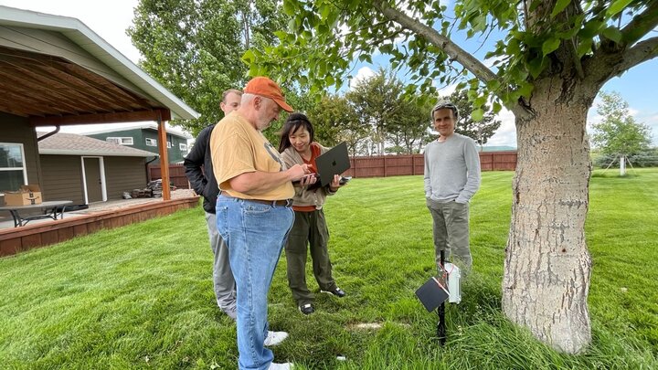
Update from Wei-zhen Liang
We have recruited 10 homeowners in Gering and Scottsbluff and deployed 14 sensors across their lawns. Early results demonstrate clear patterns: soil moisture readings spike immediately after irrigation and decline as the grass consumes water, validating the sensors’ ability to capture lawn water use cycles. Our educational component has also been active. We conducted two workshops in Nebraska and Florida. During the sessions, students learned the basics of how Internet of Things (IoT) can be used in agriculture, especially for monitoring soil moisture and crop health. We aim to leverage this pilot project to pursue larger proposals, including potential funding through the Nebraska Environmental Trust and NSF-ExLENT, while also seeking collaborations with extension educators and community partners. The 104b seed grant has been critical in helping us launch this project, and it has enabled the development of our prototype systems, student experiential learning opportunities, and homeowner engagement. This foundation will support future competitive proposals and expand research on smart lawn irrigation management.
Project title: Monitoring monthly groundwater level variation in the Nebraska Sandhills using remote sensing
PIs: Nawaraj Shrestha, co-PIs Troy Gilmore, Aaron Mittelstet, Aaron Young, R.M. Joeckel
Funding amount: $14,716
Project summary: Groundwater levels in remote areas are measured using few observation wells, limiting understanding of variability and hindering decisions. High installation, maintenance, and monitoring costs restrict observations. Yet, tracking groundwater variation is critical because these areas recharge aquifers and are vulnerable to human and climate impacts. Satellite remote sensing, such as LiDAR, can estimate water levels. Where surface water and groundwater intersect, LiDAR provides estimated aquifer hydraulic heads. This study tests LiDAR’s ability to estimate monthly hydraulic heads of the unconfined aquifer in the Nebraska Sandhills using lake levels, enabling spatial and temporal groundwater monitoring at a monthly scale.
Update from Nawaraj Shrestha
Recent research demonstrates that LiDAR-derived groundwater-level estimates show strong agreement with well data, particularly when compared to the nearest observation wells. By incorporating satellite altimetry datasets, the study enhances spatial observation density across the Sandhills region. The proposed framework successfully generates spatially continuous groundwater-level maps, offering vital insights into the Sandhills’ sensitivity to climate variability and its pivotal function in regional groundwater recharge.
104(b) grants have been critical as it has been instrumental in providing first-time PI experience. Leading a project has built confidence, capability, and momentum for federal and institutional funding. It also helped in career development, networking & mentorship opportunities through collaboration, and conference presentation and participation.
Project title: Is fish tissue methylmercury related to lake sediment methylmercury?
PIs: Chad Brassil, co-PIs Karrie Weber and Matthew Larrey
Funding amount: $29,801
Project summary: Mercury is a highly toxic metal to which humans are exposed primarily through consumption of wild-caught fish. Because of its chemical properties, mercury movement through the environment and within ecosystems is complex. In other parts of the United States (Rocky Mountains, Northeast and Southeast U.S.), the relationship between mercury in sediment and fish has either been tenuous or contingent on locally specific environmental factors.
We will quantify one part of the complex movements of mercury in the environment in the Western Corn Belt by comparing sediment mercury to lake parameters, sediment mercury to mercury to fish tissue mercury in the same lakes, and describing the makeup of sediment microbial populations with genetics. Our results will clarify how mercury moves from the sediment into aquatic food webs as a part of a larger effort to inform wild fish consumption decisions.